BDT GeoCatalogue
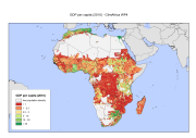
GDP per capita (2010) - ClimAfrica WP4
The Gross Domestic Product per capita (gross domestic product divided by mid-year population converted to international dollars, using purchasing power parity rates) has been identified as an important determinant of susceptibility and vulnerability by different authors and used in the Disaster Risk Index 2004 (Peduzzi et al. 2009, Schneiderbauer 2007, UNDP 2004) and is commonly used as an indicator for a country’s economic development (e.g. Human Development Index). Despite some criticisms (Brooks et al. 2005) it is still considered useful to estimate a population’s susceptibility to harm, as limited monetary resources are seen as an important factor of vulnerability. However, collection of data on economic variables, especially sub-national income levels, is problematic, due to various shortcomings in the data collection process. Additionally, the informal economy is often excluded from official statistics. Night time lights satellite imagery of NOAA grid provides an alternative means for measuring economic activity. NOAA scientists developed a model for creating a world map of estimated total (formal plus informal) economic activity. Regression models were developed to calibrate the sum of lights to official measures of economic activity at the sub-national level for some target Country and at the national level for other countries of the world, and subsequently regression coefficients were derived. Multiplying the regression coefficients with the sum of lights provided estimates of total economic activity, which were spatially distributed to generate a 30 arc-second map of total economic activity (see Ghosh, T., Powell, R., Elvidge, C. D., Baugh, K. E., Sutton, P. C., & Anderson, S. (2010).Shedding light on the global distribution of economic activity. The Open Geography Journal (3), 148-161). We adjusted the GDP to the total national GDPppp amount as recorded by IMF (International Monetary Fund) for 2010 and we divided it by the population layer from Worldpop Project. Further, we ran a focal statistics analysis to determine mean values within 10 cell (5 arc-minute, about 10 Km) of each grid cell. This had a smoothing effect and represents some of the extended influence of intense economic activity for local people. Finally we apply a mask to remove the area with population below 1 people per square Km.
This dataset has been produced in the framework of the "Climate change predictions in Sub-Saharan Africa: impacts and adaptations (ClimAfrica)" project, Work Package 4 (WP4). More information on ClimAfrica project is provided in the Supplemental Information section of this metadata.
Simple
- Date (Creation)
- 2014-06-01T00:00:00
- Presentation form
- Digital map
- Purpose
-
Purpose of WP4 - D4.3 is to establish a medium-term warning system (based on ClimAfrica data) that produces prospective analyses about climate change impacts on agriculture for the next 10 years. This will fill the gap between seasonal scale predictions and long-term impact scenarios, and identify the future Areas of Concerns (AoCs) and likely hotspots of vulnerabilities.
- Status
- Completed
- Maintenance and update frequency
- As needed
- Theme
-
-
infrastructures
-
night light
-
poverty
-
GDP
-
Gross Domestic Product
-
purchasing power parity
-
WP4
-
ClimAfrica
-
Tag_climafrica
-
- Place
-
-
Africa
-
- Access constraints
- Copyright
- Spatial representation type
- Grid
- Distance
- 30 arc/sec
- Metadata language
- English
- Character set
- UTF8
- Topic category
-
- Society
))
- Supplemental Information
-
ClimAfrica was an international project funded by European Commission under the 7th Framework Programme (FP7) for the period 2010-2014. The ClimAfrica consortium was formed by 18 institutions, 9 from Europe, 8 from Africa, and the Food and Agriculture Organization of United Nations (FAO).
ClimAfrica was conceived to respond to the urgent international need for the most appropriate and up-to-date tools and methodologies to better understand and predict climate change, assess its impact on African ecosystems and population, and develop the correct adaptation strategies. Africa is probably the most vulnerable continent to climate change and climate variability and shows diverse range of agro-ecological and geographical features. Thus the impacts of climate change can be very high and can greatly differ across the continent, and even within countries.
The project focused on the following specific objectives:
1. Develop improved climate predictions on seasonal to decadal climatic scales, especially relevant to SSA;
2. Assess climate impacts in key sectors of SSA livelihood and economy, especially water resources and agriculture;
3. Evaluate the vulnerability of ecosystems and civil population to inter-annual variations and longer trends (10 years) in climate;
4. Suggest and analyse new suited adaptation strategies, focused on local needs;
5 Develop a new concept of 10 years monitoring and forecasting warning system, useful for food security, risk management and civil protection in SSA;
6. Analyse the economic impacts of climate change on agriculture and water resources in SSA and the cost-effectiveness of potential adaptation measures.
The work of ClimAfrica project was broken down into the following work packages (WPs) closely connected. All the activities described in WP1, WP2, WP3, WP4, WP5 consider the domain of the entire South Sahara Africa region. Only WP6 has a country specific (watershed) spatial scale where models validation and detailed processes analysis are carried out.
- Reference system identifier
- GCS WGS 84 (EPSG Ellipsoid 7030)
- Distribution format
-
-
(
GeoTiff
)
-
(
GeoTiff
)
- OnLine resource
-
L07_GDPpercapita.zip
(
WWW:DOWNLOAD-1.0-http--download
)
GDP per capita
- OnLine resource
-
Scenarios of major production systems in Africa
(
WWW:LINK-1.0-http--link
)
Project deliverable D4.1 - Scenarios of major production systems in Africa
- OnLine resource
-
CLIMAFRICA – Climate change predictions in Sub-Saharan Africa: impacts and adaptations
(
WWW:LINK-1.0-http--link
)
Climafrica Website - Climate Change Predictions In Sub-Saharan Africa: Impacts And Adaptations
- File identifier
- e6c167cf-fd37-4384-8a02-1006e403f529 XML
- Metadata language
- English
- Character set
- UTF8
- Date stamp
- 2023-01-24T08:43:48
- Metadata standard name
-
ISO 19115:2003/19139
- Metadata standard version
-
1.0
Overviews

Spatial extent
Provided by