BDT GeoCatalogue
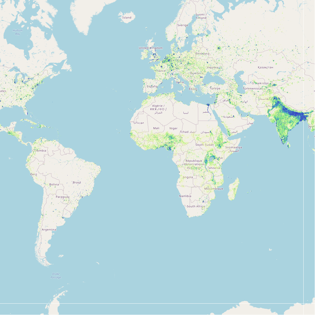
Human Population Density (Global - Annual - 1 km)
Estimated density of people per grid-cell, approximately 1km (0.008333 degrees) resolution. The units are number of people per Km² per pixel, expressed as unit: "ppl/Km²". The mapping approach is Random Forest-based dasymetric redistribution.
The WorldPop project was initiated in October 2013 to combine the AfriPop, AsiaPop and AmeriPop population mapping projects. It aims to provide an open access archive of spatial demographic datasets for Central and South America, Africa and Asia to support development, disaster response and health applications. The methods used are designed with full open access and operational application in mind, using transparent, fully documented and peer-reviewed methods to produce easily updatable maps with accompanying metadata and measures of uncertainty.
Acknowledgements information at https://www.worldpop.org/acknowledgements
Simple
- Date (Revision)
- 2018-10-24
- Edition
-
3.0
- Presentation form
- Digital map
- Other citation details
-
For all WorldPop datasets, please cite the WorldPop website as the source: www.worldpop.org. Additionally, for the Random Forests Population modelling script (wpRFPMS ) the suggested citation is the following: Bondarenko M. , Nieves J. J., Stevens F. R., Gaughan A. E., Tatem A. and Sorichetta A. 2020. wpgpRFPMS: Random Forests population modelling R scripts, version 0.1.0. University of Southampton: Southampton, UK. 10.5258/SOTON/WP00665
- Purpose
-
WorldPop datasets have been downloaded by researchers and policy makers from countries across the World, including 95% of the countries mapped by the project, resulting in valuable feedback and improvements to products. The data have been downloaded and used by a wide range of governments agencies. WorldPop outputs have been obtained and utilized by many international organizations, foundations and agencies including UNDP, UNEP, FAO, WHO, The World Bank, WFP, WWF, USGS, Red Cross International and UNOCHA.
- Status
- On going
- Theme
-
-
people
-
humans
-
Modeled global distribution
-
WorldPop
-
HiH_Humans
-
Tag_HiH
-
- Place
-
-
Global
-
- Temporal
-
-
Annual
-
- Spatial representation type
- Grid
- Metadata language
-
eng
- Topic category
-
- Geoscientific information
- Society
- Planning cadastre
- Economy
- Environment description
-
GeoTiff
))
- Begin date
- 2000-01-01
- End date
- 2020-12-31
- Supplemental Information
-
Data Type: "Float32"
No Data value: -9999
- Reference system identifier
- GCS_WGS_1984
- Number of dimensions
- 2
- Dimension name
- Row
- Dimension size
- 21600
- Resolution
- 0.00833333 DecimalDegree
- Dimension name
- Column
- Dimension size
- 43200
- Resolution
- 0.008333333 DecimalDegree
- Cell geometry
- Area
- Transformation parameter availability
- No
- Distribution format
-
-
GeoTIFF
(
1.0
)
-
GeoTIFF
(
1.0
)
- OnLine resource
-
PPL_D:YEAR:YEAR
(
OGC:WMS-1.3.0-http-get-map
)
Human Population Density - WorldPop (Global - Annual - 1 km)
- OnLine resource
- Download data from the Worldpop official website ( WWW:LINK-1.0-http--link )
- Statement
-
The method used for mapping the population density is based on the Random Forest-based dasymetric scripts. The wpRFPMS is a population modelling R script utilizing Random Forests to inform a dasymetric redistribution of census-based population count data. Read more about the method at https://doi.org/10.1371/journal.pone.0107042. All census data, zonal stats and covariates for 249 countries are stored on WorldPop FTP and downloaded into a project by using the R package at https://github.com/wpgp/wpgpCovariates.
- File identifier
- 304c21fb-0f5a-44ad-9948-2af6a7144fb5 XML
- Metadata language
-
eng
- Character set
- UTF8
- Hierarchy level
- Dataset
- Hierarchy level name
-
dataset
- Date stamp
- 2022-01-10T16:43:33
- Metadata standard name
-
ISO 19115:2003/19139
- Metadata standard version
-
1.0
Overviews
Spatial extent
Provided by